The United States is a country built on the theft of land from indigenous peoples.
It’s something that most of us ignore, but on a daily basis, everyday we walk on stolen land. At the time Christopher Columbus “discovered” the Western hemisphere, what now constitutes the United States was a land entirely inhabited by indigenous nations who had developed complex lifeways. Estimates place the native population at 70 to 100 million people in 1492.iii Across the hemisphere, people had developed diverse modes of living in general harmony with the land bases they inhabited. Indigenous people throughout the hemisphere were connected by networks of trails, trade routes, and exchange.iv
The story of what happened after Columbus arrived has been told in many different places. At the risk of collapsing numerous experiences into a single narrative, it was a process of genocide. In the 500 years since, Native populations have been subjected to an ongoing process of colonization, with their traditional lifeways destroyed, their lands stolen, and their people murdered. The history of what would become the United States is in many ways a history of this theft. The United States’ government (as well as European colonial powers such as Britain and France) acting aggressively to seize what wasn’t theirs. The land bears the scars of this conquest, bathed in the blood of massacres, biological warfare, and attempts to eradicate entire cultures. The maps we use—states carved up out of what were once vast largely borderless areas—reveal some of this history. Names of many states, cities, and counties contain references to the indigenous inhabitants, names stolen and often misspelled. Colonization was the clearing not only of the landscape under the guise of commodification, but also of entire populations.
There isn’t an area of the United States untouched by this legacy and those of us of European descent are the inheritors and benefactors of conquest. The policies of colonization varied from place to place and differed in intensity, but the process of attempting to dispose people of their land is never pleasant and everywhere it happened there are stories of horror.
In this way, what we now know as “Grand Rapids” is no different. It was built on native land, slowly stolen over a process of years. The founding and growth of the city was based on an ongoing attempt to destroy the indigenous people who inhabited the area. The white settlers who came here were colonizers and their behavior was part of the colonial project. Colonial conquest in Grand Rapids involved the use of alcohol as a weapon, treaty making, forced removal, and theft of land. As an ideology, colonization included the belief in the superiority of peoples of European descent, a hostility to indigenous cultures, and a belief in the domination of the natural world. Colonization is not something that ends at a specific time—for example the date of the last treaty with the Ottawa (or Odawa)v in 1855—but instead it is a set of ideas and a way of seeing the world that has ramifications in the present day.
The Indigenous Inhabitants
At the time of contact with Europeans, the area surrounding what would be Grand Rapids was inhabited by a large number of indigenous groups. The people living in what is now called Michigan—including the area now known as Grand Rapids—were inclined to identify with kinship groups and bands.vi Groups were centered in specific geographic areas and members of the groups had intimate knowledge of the land in their region.vii After this local and/or kinship identification, they would probably have identified as Anishinaabeg.viii The Anishinaabeg were the latest indigenous group to inhabit the area, coming to the general area around 1,000 years ago after migrating from the east coast of what would become Canada and the United States.ix Prior to the arrival of the Anishinaabeg, the area was home to other indigenous groups, at least some of whom had similar lifeways and are believed by anthropologists and historians to either have moved further west or melded into the Anishinaabeg groups. Even earlier than that, the Grand River valley was home to an indigenous group that is called the Hopewell by archaeologists. They are known for their large earthen burial mounds which dot the Midwest. According to various sources, the Anishinaabeg people at the time of European contact did not know who built the mounds, but respected them as prior inhabitants.
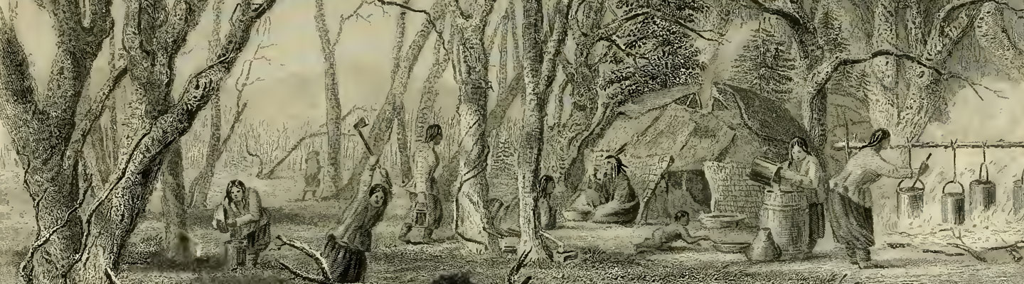
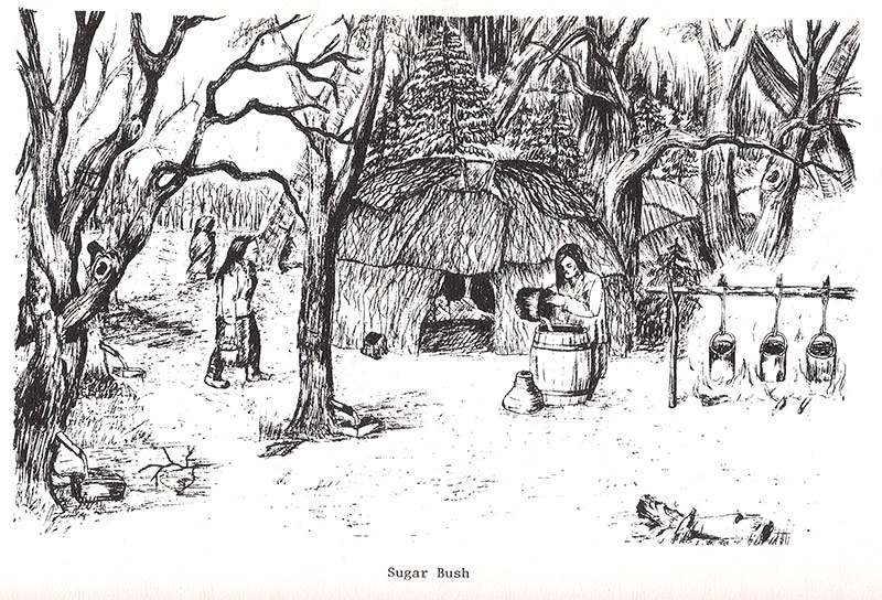
The Anishinaabeg lived in close harmony with the land, which they depended on for their survival. They had a comprehensive spiritual worldview which saw humans and the natural world as interconnected without the sense of separation that characterizes western thought.x They depended on a combination of agriculture, hunting, and fishing for survival, with their varied food sources helping to ensure their survival if one area was unsuccessful.xi They had complex understandings of the eco-systems and bio-regions they inhabited leading to – for example – hunting throughout the territory to avoid overkill and using nearly every part of the animal.xii Plants from the forest were essential sources of medicine.xiii For hundreds of years the forest provided indigenous groups with food, shelter, and clothing. People were grouped into semi-autonomous units with strong bonds of kinship connecting groups across the region.xiv On a day-to-day basis, the Anishinaabeg lived in semi-permanent villages of around 75-100 people, often made up of 10 to 20 different households.xv Villages were typically located along rivers and surrounded by small agricultural efforts.xvi Individual bands would move at different points during the year, often related to the seasons and shifts in activities, such as hunting in the winter and maple sugaring in the spring.
Anishinaabeg society was “decidedly egalitarian” according to many historians, with a strong concept of individual liberty. Small bands freely associated as needed and came together at various points of the year for celebrations.xvii The concept of leadership was fluid, with people – regardless of gender – gaining positions of influence based on respect and skill. The Anishinaabeg valued generosity, virtue, and humility in leaders.xviii That said, they still could only make suggestions, they could not compel people into doing something.xix There was a strong sense of group cohesion as the Anishinaabeg understood that their survival was dependent on being part of the group.xx They had also developed rich and varied cultural traditions characterized by ceremonies, spiritual beliefs, and oral traditions. Oral traditions provided a means of rooting the Anishinaabeg in their environment and passing on cultural values. The knowledge of centuries was passed down from generation to generation through everyday life. This included the skills, rituals, songs, dances, and lifeways.xxi These oral traditions situate the Anishinaabeg in this general region for hundreds of years before contact with white men.xxii
Of course, such a brief description will necessarily leave out nuance and obscure the complexity of Anishinaabeg lifeways. But it is important to understand that contrary to what colonialist histories purport, the lands in what would become Michigan were occupied by rich and vibrant communities. Unlike the modern civilization where proponents of the existing order speak of “sustainability” and an advanced technological and industrial economy, these were truly sustainable lifeways guided by the land of which they were a part.
First Contact and the Founding of “Grand Rapids”
Louis Campau, a fur trader, settled in the area that we now know as Grand Rapids in 1826. Following a survey of the east side of the Grand River in 1831, there was an influx of settlers beginning in 1833.xxiii These events began the migration of white settlers into the region, ending in the founding of Grand Rapids. Consequently, the city that would be come Grand Rapids was established in 1834 as the township of “Kent”. Its name was later changed to “Grand Rapids” in 1842 and was incorporated as a city in 1850.
However, Europeans had visited the area of Grand Rapids before Campau’s arrival. The Grand Rapids area Odawa Chief Noahquageshick (often referred to as “Noonday” by Europeans) recalled a trading cabin in Grand Rapids in 1806.xxiv Other Odawa accounts say that the first visit to what would be Grand Rapids occurred in 1748.xxv Still other works state that is likely an early missionary was among the Grand River groups in 1799.xxvi In the early part of the 19th century, a trading post was established two miles west of Lowell.xxvii The French, who established extensive trading networks in what would become Michigan, had missionaries in Michilimackinac in 1616 and claimed to have visited every native village in the state.xxviii This places the date of initial encounter significantly earlier. However, from the 1821 effort to establish a mission amongst the Odawa to 1833, the Grand Rapids area was essentially “Indian country” (to borrow a colonial phrase) with a small mission and a small number of traders.xxix
Contrary to the myths of colonial history, the settlers did not move into uninhabited land, rather, they moved into an area that was populated by a number of different indigenous groups. In what would become Grand Rapids, there were two villages on the west side of the Grand River. One was located near Bridge Street and the other close to where West Fulton intersects with Watson.xxx A bronze plaque marking the site of the southern village was placed at the intersection of Fulton and National in 1917.xxxi Despite the influx of settlers, the indigenous inhabitants remained a visible presence. In 1837, John Ball wrote of the Odawa population of the Grand River valley:
“…a cultivated field [near Indian Mill Creek] was planted with corn, which the women well hoed. The men fished and hunted. They lived all up and down the river, and through the country.”xxxii
The Catholic missionary Frederic Baraga reported a population of 900 natives in 1833.xxxiii In 1837, Henry Rowe Schoolcraft (a U.S. government representative who studied indigenous cultures) estimated the Odawa population in the Grand Rapids area at 1,053xxxiv. These included the following villages in the region:
- Rain’s Band? – 164
- Fort Village G.R. – 156
- Little Prairie G.R. – 53
- Grand Rapids – 166?
- Prairie Village G.R. – 47
- Thornapple River G.R. – 106
- Forks G.R. – 76
- Flat River G.R. – 135
- Maple River G.R. – 150
As a result of contact, the lifeways of the Anishinaabeg people in the region changed dramatically. Due to the pressures of European fur traders, hunting gained prominence in Anishinaabeg life.xxxv Social organization also began to change, with what was apparently a looser form of group identity, coalescing into something more specific.xxxvi At least in part, this was largely motivated by the Europeans inability to understand the autonomous nature of Anishinaabeg communities. Europeans – who had begun the process of forming large nation states – sought specific groups of indigenous peoples with whom they could trade and negotiate. For example, the development of an “Odawa” or “Ottawa” identity was at least partially influenced by European contact. Odawa oral traditions recall that the Odawa received their tribal name when European explorers asked the Natives “where are you going?” – and not knowing English – they replied with “doo-adow-weh” which means peddling or trading, thus their name to the Europeans became “Ottawa”.xxxvii Similar stories past down through the generations attribute the names of other Three Fires’ people in a similar manner. Along with this, the concept of a tribe or unified group emerged which united related groups into a larger entity. This was helpful for the Europeans and later the U.S. government who sought large blocs of people with whom to negotiate, but it was difficult for the Anishinaabeg people who were used to small groups making decisions on their own. Along with this, the European designation of Anishinaabeg people as “chiefs” or leaders was at odds with longstanding traditions of egalitarianism in Anishinaabeg life.xxxviii
The Land at the Time of Conquest
The land that would become Grand Rapids looked dramatically different than the landscape of today, or even that of a few decades after settlers came to the region.
A description compiled in 1934 from primary sources does a good job of depicting the lay of the land at the time of settlement by white people:
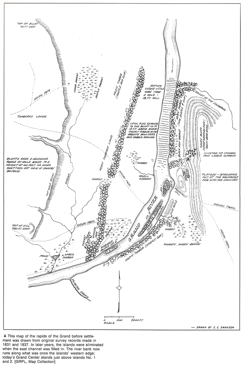
“The land east of the river was different from the land on the west side. There was a narrow border of low land next to the river bank on the west side. Back of this were high hills. On the east side, right where the business part of the city is today, was a mass of ground which the early settlers called Prospect Hill… some distance from the east bank of the river there was a sand hill.
The trees growing in the valley and on the hills were of many kinds. On the hills were black and white oak. Along the river bank and about the swamp holes were many willows. Large elms grew along the river banks and on the low grounds where the railroads now run. The four islands in the river were also covered with elms. The big gravel hill on the west side was covered with hickory trees. Here also were forests of sycamores whose white trunks and branches gave beauty to the country. Northwest of what is now Grand Rapids were many pines and also a cedar swamp. Along the hills on either side of the river grew many soft and silver-leaf maples. There were a few walnut and plum trees, and plenty of grapevines. In the swampy lands grew huckleberries and cranberries, and in the woods grew bushes of red and black raspberries.”xxxix
The land was in an isolated location in the middle of a vast wilderness. In 1821 when the Baptist missionary Issac McCoy came to the Grand River to establish a mission, only “well-worn” native trails led to the city, cutting through the vast forest.xl An 1833 account of settlers coming to the Grand River described the settlement as being very small and “all about were woods.”xli
Early accounts of Grand Rapids speak to the beauty of the land, much of which was lost as settlement proceeded. The historian Albert Baxter wrote that “The site was one of great natural beauty, charming for its great variety of features in landscape.”xlii Z.Z. Lydens, another prominent historian of Grand Rapids wrote:
“The scene from the top of the hill … was rapturous. The wooded slopes and the rippling river, bejeweled with emerald isles, and the high rise to the west that foreshortened the sunset, were a majestic array to gladden the heart of the beholder.”xliii
An 1837 account of the town gave a vivid description:
“To ascend these bluffs, you take a gradual rise to the height of a hundred feet, when the horizon only limits the extent of vision. The scenery to an admirer of beautiful landscape is truly picturesque and romantic. Back, east of the town, is seen a wide-spread plain of burr-oak, at one easy to cultivate, and inviting to the agriculturist. Turning westward, especially at the setting of the sun, you behold the most enchanting prospect — the din of the ville below — the broad sheet of water murmuring over the Rapids — the sunbeams dancing upon its swift-gliding ripples — the glassy river at last losing itself in its distant meanderings — present a scenery that awakens the most lively emotions. But the opposite shore, upon which you behold a rich, fertile plain, still claims no small amount of admiration.”xliv
John Ball wrote that outside of Grand Rapids:
“All was a grand and noble forest, with its tall pine, its sugar tree and beech, and the sturdy oak scattered over what are called the “openings.” These opening lands extended along generally on both sides of the river to a greater or less distance back, through Kent and Ionia counties, up the Flat River to Greenville, and along the east side of the Thornapple.”xlv
These brief views, while focusing primarily on the beauty and geography of the land, give a sense of what once was. From the descriptions of abundant forests and rivers, it is easy to see how the land was able to sustain the indigenous population for centuries. Another excerpt from Albert Baxter’s 1891 history focuses on how the forest sustained people and how quickly the white settlers destroyed those sources of life:
“In the early days game of many kinds, and fish, were abundant; but of the native meats, except fish, the near-by supply is exhausted. Fish are yet taken from the river and adjacent waters in considerable quantities; but the bear, the deer and the wild geese, ducks and turkeys, partridges and quails, are no longer the ready victims of the huntsman for the morning meal.
By the pioneers, wolves, bears and wildcats were often encountered, and even so late as 1856 wild bears were sometimes seen perambulating the streets of the city.
Deer and bears had a “runway” crossing the river at the still water just above the rapids. But their day is long since passed. And even the song birds whose music once enlivened the woods, and the wild honeybees that stored sweetness in the trees, and the wild berries, and many varieties of beautiful flowers of the forest and the openings, have dwindled away – almost gone, abashed, from the presence of the white man.
And the grand, natural parks and groves and thickets, of maple, and elm, and oak, and hickory, and black walnut, and linden, and pine – these have been cut away – utterly destroyed – except such occasional small patches as are needed for farm and family uses.”xlvi
Endnotes
i Unsettling Minnesota, Unsettling Ourselves: Reflections and Resources for Deconstructing Colonial Mentality, (2009), https://unsettlingminnesota.files.wordpress.com/2009/11/um_sourcebook_jan10_revision.pdf 42.
ii Andrew J. Blackbird, History of the Ottawa and Chippewa Indians of Michigan, (Ypsilanti: Ypsilantian Job Printing House, 1887), 102.
iii Gord Hill, 500 Years of Indigenous Resistance, (Oakland: PM Press, 2009), 7.
iv Roxanne Dunbar-Oritz, An Indigenous Peoples’ History of the United States, (Boston: Beacon Press, 2014), 27-30.
v In this piece, we generally use the word “Odawa” when referring to the Anishnaabeg people often referred to as “Ottawa” in colonial histories. We prioritize the usage of “Odawa”–a word that is likely derived from the Anishnaabe term for “trading” or “trader”. This word was likely corrupted by the French as “Ottawa” and used as a name for the Anishnaabeg people they encountered. We generally use the “Ottawa” spelling when referring to official treaties.
vi Charles E. Cleland, Rites of Conquest: The History and Culture of Michigan’s Native Americans, (Ann Arbor: University of Michigan Press, 1992), 39.
vii Cleland, 43-44.
viii Cleland, 39.
ix Phil Bellfy, Three Fires Unity: The Anishinaabeg of the Lake Huron Borderlands, (Lincoln: University of Nebraska Press, 2011), xxxvii.
x James M. McClurken, “The Ottawa”, in People of the Three Fires: The Ottawa, Potawatomi, and Ojibway of Michigan, (Grand Rapids: Grand Rapids Inter-Tribal Council, 1988), 6.
xi McClurken, 4.
xii Pamela J. Dobson, ed., The Tree That Never Dies: Oral History of the Michigan Indians, (Grand Rapids: Grand Rapids Public Library, 1978), 23.
xiii Dobson, 73.
xiv Bellfy, 15.
xv Cleland, 47.
xvi Cleland, 47.
xvii Bellfy, 15.
xviii Cleland, 59.
xix McClurken, 5.
xx McClurken, 5.
xxi Dobson, 43.
xxii Howard Webkamigad, Ed. and Trans., Ottawa Stories from the Springs, (East Lansing: Michigan State University Press, 2015), 183.
xxiii Z.Z. Lydens, ed., The Story of Grand Rapids, (Grand Rapids: Kregel Publications, 1966), 105.
xxiv Albert Baxter, History of Grand Rapids Michigan, (New York: Munsell & Company, 1891), 45.
xxv Baxter, 45.
xxvi M.A. Leeson, History of Kent County, Michigan, (Chicago: C.C Chapman & Co., 1881), 191.
xxvii Baxter, 26.
xxviii Baxter, 49.
xxix Baxter, 1.
xxx Baxter, 28.
xxxi Lydens, 618.
xxxii Baxter, 78.
xxxiii Lydens, 464.
xxxiv Patrick Russel LeBeau, Rethinking Michigan Indian History, (East Lansing: Michigan State University Press, 2005), 168.
xxxv W. Vernon Kinietz, The Indians of the Western Great Lakes, 1615-1760, (Ann Arbor: University of Michigan Press, 1965), 235.
xxxvi Cleland, 39-40.
xxxvii Dobson, 120.
xxxviii Bellfy, 15.
xxxix The Story of Grand Rapids, Mich., (Grand Rapids: Board of Education, 1932), 15-16.
xl Baxter, 49.
xli Baxter, 55.
xlii Baxter, 6.
xliii Lydens, 4.
xliv Baxter, 69.
xlv Baxter, 78.
xlvi Baxter, 9.